Most of my adventures are solo, but on this particular trip I had a traveling companion - hereinafter referred to as "T.C." I will list the highways we took, and you can look them up on a map if you wish. We went in my car and we spent almost a month exploring in Mexico. Again, as with all my adventures, it was my plan to travel on a budget. I don't stay in the cheapest places by any means, but I like to experience the "flavor" of a country instead of staying in fancy hotels that could just as well be in the U.S. I had the idea that the trip would cost each of us no more than $50 a day. (T.C. and I were not "romatically involved," and although we stayed in the same hotel room for convenience, we each extended privacy to the other.)
Traveling by car in Mexico, special considerations must be made. U.S. car insurance is not valid when driving to the interior of Mexico. Auto insurance for Mexico can be purchased through AAA (among a few other sources), where one can also obtain information about additional documentation required. (Also, be sure to get a good road map of Mexico. AAA has those as well.) The insurance for my car was approximately $300 for the month I would travel in Mexico.
Along with your passport (or other valid proof of citizenship), be sure to take your car registration. At the border you must obtain a permit to take your vehicle into Mexico for the specified length of time.
The loosely formatted plan was to first visit Real de Catorce, an old silver mining town, then continue to Guadalajara and the Ajijic/Lake Chapala area where we'd stay for a while. (T.C. lived for several years in Ajijic - which is pronounced ah-hee-HEEK.) Then we planned to travel to San Miguel de Allende, visiting several other towns en route, and remain in San Miguel for several days.
June 29, 1999
After having spent the night in Corpus Christi with friends of T.C., we continued to McAllen and crossed the border at Reynosa, where getting a permit to take the car into Mexico turned out to be a lengthy process. It was necessary to wait in three different long lines. The procedure itself took about three hours, but we were further delayed - shortly after we arrived at the border checkpoint, T.C. went to the car to get something. When I saw him standing by my car, looking befuddled as he checked and re-checked his pockets, I correctly concluded that he had locked the keys inside. Various attempts to open the car were unsuccessful. Finally, a very nice Mexican woman (from Houston, incidentally) drove into town and brought a locksmith.
It was mid-afternoon before we were on our way again. We headed southwest on Highway 40, then turned south on 35. Traveling after dark in Mexico is not a good idea. Because of the long delay in Reynosa, we knew we would not make it all the way to Real de Catorce, the destination we had intended for the first day. We'd go as far as we could before stopping for the night.
Starting before we reached the town of China, the desert was splashed with beautiful lavender blooms of sage. We continued through Montemorelos, and near dark stopped in Linares. From Corpus Christi the day's trip had been about 290 miles.
Parking is often difficult in Mexico and having at least two people on a car trip helps - one can circle the block while the other inspects hotel rooms for acceptability. After checking several hotels in Linares, we chose the Park Villa Hotel. (220 pesos, or about $24.) Indoor secure parking was available, which is important in many towns in Mexico - otherwise, your car might be broken into during the night.
June 30, 1999
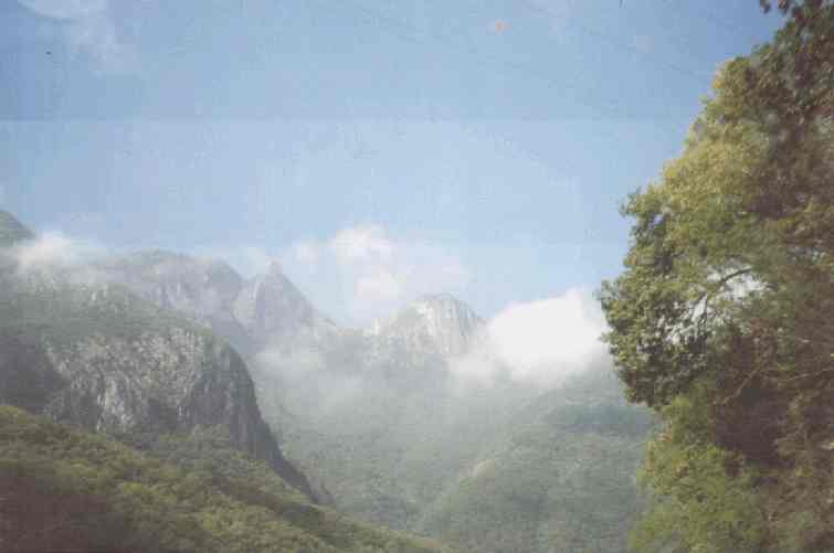
Leaving Linares on Highway 58, we soon saw huge cloud-shrouded mountain peaks ahead. (To see a picture of the mountains as we entered them, click HERE.)We were entering the Sierra Madre Oriental - and the cooler weather of the mountains (while most of the U.S. and the lower elevations of Mexico were suffering from a massive heat wave during this time).
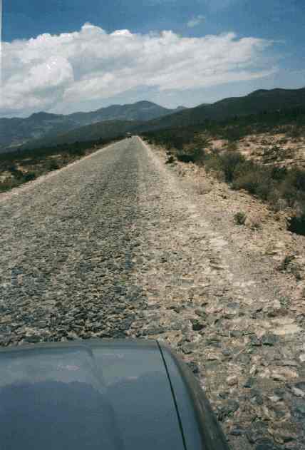
Crossing the twisting, winding roads of the mountain range offered breathtaking vistas, one after another. We turned south on Highway 57, and much of the high desert there was a virtual forest of cactus. Traveling on apparently level ground for a while, we were headed toward still more mountains. We intended to turn west on a small side road just before Matahuala and go to Real de Catorce, but for some reason, not a single gas station was open along the way. We made it on fumes to Matahuala, gassed up, and retraced a couple of miles to our turnoff. (By the way, all the gas stations - Pemex - are state-owned. The restrooms may or may not be clean and well supplied, so on a Mexico road trip be sure to take toilet paper, toilet seat covers, and handi-wipes for cleaning your hands.)
The last 20 miles before Real de Catorce were rough cobblestone, and maximum speed was about 30 mph. (To see a picture of the cobblestone road, click HERE.) We were in high-desert country and the road seemed fairly level, but actually the elevation was rising significantly. Finally the road ascended sharply as we started seeing ruins of the outlying city.
Continuing up and around a mountain, we reached a two-mile one-way tunnel that lead to the main part of Real de Catorce. It is said that during the silver mining days, two different teams of miners were digging for silver from opposite sides of the mountain, and by chance, they met in the middle. The story seemed reasonable because at one point, we suddenly came to a 90-degree turn in the black hole of the tunnel; it was a spooky feeling, because at first it seemed that the tunnel had just...ended. (To see a picture of the tunnel just as we were getting to the end - and seeing "the light at the end of the tunnel", click HERE.)
After emerging from the tunnel, we drove up a steep hill and around
a corner - and suddenly halted as we came upon the road entering the town.
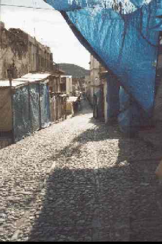
The street looked far too narrow to drive a car through. It had open-air
shops on both sides and was crowded with people. As we sat in the idling
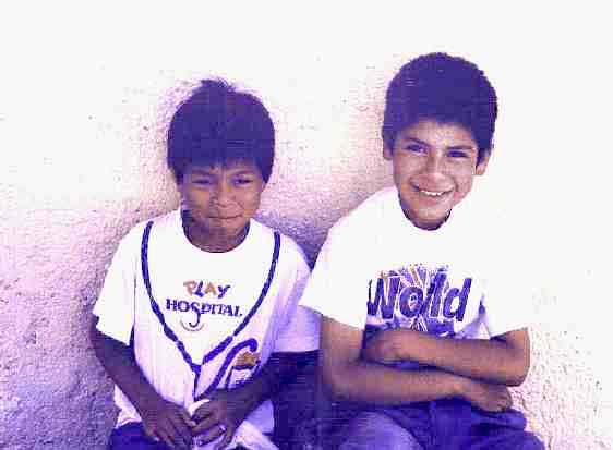
car with puzzled expressions, a couple of young boys hopped on the trunk
of the car and offered to guide us. "Adelante, " they said. (Straight ahead.)
I was apprehensive about having them ride on the trunk, but it soon became
apparent that they were old hands at it - and of course our speed was only
about 10 miles per hour. People moved out of the way as we made our way
slowly through the narrow street. (To see a picture of the narrow road
as we entered the town, click HERE.) The picture was taken at the end of the day when the shops were closed
and the people had gone home.To see a picture of our darling little guides,
click HERE.
There are few cars in town. Most people get around the steep streets by foot or on horseback. The boys guided us to the other end of town where we inspected one hotel, then we doubled back to look at others.
We ended up staying at the Meson de la Abundencia (240 pesos, or about $26). It was a lovely room with a charming terrace that overlooked part of the town below. The beautiful surrounding mountains were quite near. The open windows had no screens, and the cool, pure mountain air smelled delightful. At night the sky was filled with bright stars. The silence was palpable, broken only by the occasional barking of a dog or the drawn-out braying of a jackass.
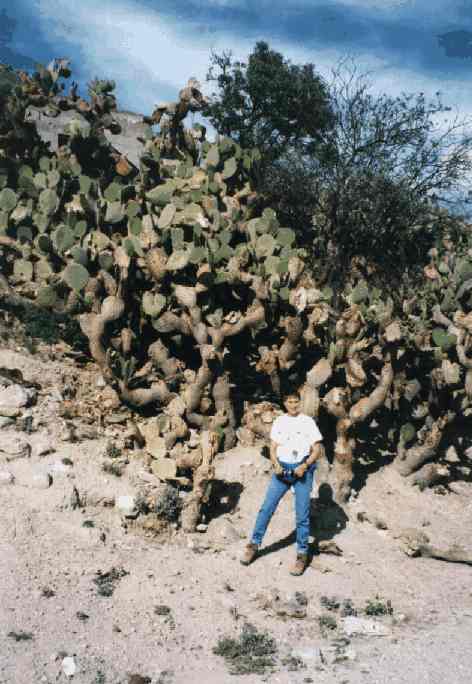
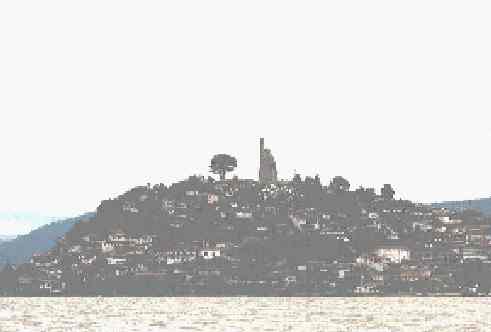
Real de Catorce has a ethereal feeling. The ruins are wonderful, and many photography workshops come to photograph the town and ruins under the beautiful, constantly changing sky. (To see a picture of the town, click HERE. Many of the buildings are unoccupied ruins. (This trip was before digital cameras, and my scanned photos aren't nearly as clear and wonderful as digital photos.) For a picture of me standing in front of some giant cactus, very typical in the area, click HERE.)
At the peak of the mining activity 100 years ago in Real de Catorce, the town had a population of about 60,000. Now there are about 2,000. However, in the 1930's after the Revolution, only a handful lived here. Then St. Francis of Assisi (known as "Panchito") performed a miracle impressive enough that the news spread widely. Mexicans in need of miracles began coming here from all parts of the country, giving Catorce the economic boost it so badly needed.
To this day, pilgrims continue to flock here at times. The biggest crowds are in early October to mark the saint's feast day. Often they return to thank Panchito for a miracle in their lives. In the church a room is lined floor to ceiling with small oil paintings called retablos, done by pilgrims as offerings to the saint. They depict in detail the accident or situation so Panchito would know precisely which miracle he was being thanked for. These tiny art works have become an internationally recognized art form and command a fair price on the market.
July 1, 1999
Leaving Real de Catorce at 10:00 a.m., we went back through the tunnel and over the 20 miles of cobblestone. When we reached the main road, we headed northwest, and then turned south when we reached Highway 54. This road is one of the most heavily traveled by trucks in Mexico and it is fairly narrow, rough, and has no shoulder.
Near Zacatecas we crossed the Continental Divide. From Zacatecas on almost to Guadalajara, we encountered more spectacular mountain driving but the roads were in excellent condition. We arrived Guadalajara at 6:00 p.m. (380 miles later). Guadalajara is a big, lovely modern city - and it has all the problems big-city life. There is reportedly much crime, and parking on the street at night is asking to have the car broken into. We gassed up ($2.08 per gallon for premium), and continued the approximate 20 miles on to Ajijic/Lake Chapala.
Lake Chapala, ringed by high, forested mountains and fishing villages, is Mexico's largest lake. The area surrounding it is popular with vacationers because of the near-perfect climate, and there's a large permanent expatriate population living in settlements along the shoreline and in the villages of Chapala, Ajijic and Jocotepec and those in between.
The rainy season is approximately June to October, when cooling rainstorms almost every afternoon or night bring forth bright bursts of flowers everywhere.
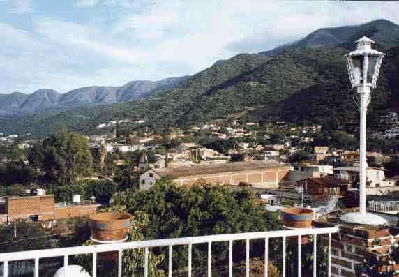
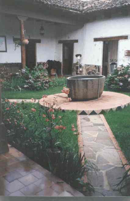
After inspecting several hotels, we chose to stay at Italo's Hotel (also called the Mariana) in Ajijic. It was 230 pesos, or about $25.00, and a week's stay was 1,288 pesos (about $140, or $20 per night. Our room was wonderfully comfortable. A large second-floor corner room with big windows on two sides, from which we had stunning views of the nearby mountains. Good reading lamps. Plenty of hot water. Even a small refrigerator. The owner, Italo, was very sweet. From the garden he picked roses for me and put them in a vase. Italo told us it was safe to park on the street in front of the hotel, which we did with no problems. (To see a view taken from the rooftop of the hotel - which was similar to the view from our window - click HERE.)
We stayed in Ajijic for seven nights. Several times a pickup truck loaded with mangos passed below our room, a loud speaker advertising them at 12 for 10 pesos - little more than a dollar! Almost every night we had a lovely rain. We visited with a few of T.C.'s friends from when he lived there before, and I did a hike up the mountain with two of them. (My compadres were like mountain goats, but I was surprised to find that it was a grueling hike for me - I was not used to the approximate 6,000-foot elevation.) At certain places during the hike we had magnificent views of the lake. At one point when I felt exhausted, I stopped and put out my hand to lean against a tree. BIG MISTAKE! I don't know the name of the tree but it had sharp spikes about an inch long protruding from all over the trunk. Needless to say, I withdrew my hand quickly!
Most of the streets in town are rough cobblestone, but the main highway through town is a good paved road and has a wonderful bike path that extends for miles beside it. One day I did a 45-minute run on the bike path. My body had been craving its exercise! (I did this run the day before the hike up the mountain.)
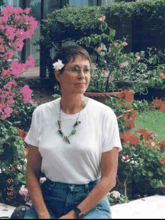
We had lunch at various places, and one of them was the terrace of the lovely Hotel Real de Chapala, where we had a wonderful view of the lake. During our meal, birds perched on the table to be fed crumbs from bollios - which are delicious rolls. Afterwards, we strolled through the lush grounds and marveled at the beauty of the abundant flowers, trees and plants. (To see a picture of me among the flowers in the hotel grounds, click HERE.)
July 8, 1999
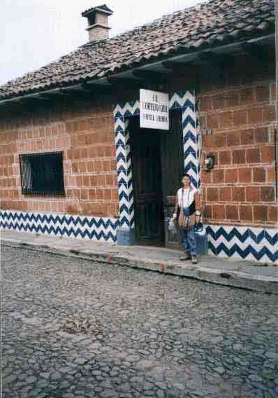
We left Ajijic and headed along the south side of Lake Chapala for Mazamitla, a beautiful resort town in the mountain zone of the state of Jalisco. The trip was only about 60 miles, but over a twisting, turning road through the mountains to about 7,000 feet elevation. First we visited a very fancy hotel outside of town (Monteverde - we didn't even ask the price), and walked through the beautiful grounds with a profusion of flowers. Then we headed back into town to look for a place to stay. We chose the hotel Cortijo Azul - 120 pesos, or about $13! That was for both of us - not each. (To see a picture of the outside of the hotel, click HERE.)
I think the hotel had recently reopened after being closed. We were the only guests. They had a driveway that entered off the street through big doors, and they allowed us to park inside for security. They had a clothes line strung across, and clothes hanging out to dry, which they cheerfully took down.
The few rooms of the hotel were built around a courtyard filled with flowers. Doors to the rooms were ancient thick wood, with huge black iron keys. Our room was charming, but we soon found that the toilet was going to stop up and they put us in the room next to it, in which the wood floors slanted like those in a fun house. The room was comfortable enough, though, and the toilet flushed well! (To see a picture of the interior courtyard, click HERE.)
Mazamitla's weather can be described as semidry, with dry winters and springs. The weather is said to be generally comfortable, and winter is not really defined. Mazamitla is in the mountains - in the Sierra del Tigre Mountain Range - and it is surrounded by cedar and pine forests. Before arriving in this area, our travels had not taken us through any other places in which the buildings were constructed of wood. The town is rustic, with houses and building painted in white, with red-tile roofs, and wood doors and columns. The whole town itself can be considered an architectural attraction. To see a picture of the church on the main square, click HERE.)
Mazamitla is a wonderful place simply to rest and commune with nature. Los Cazos is a residential area at Mazamitla and one of the many natural attractions. It is a surrounded by woods and mountains. Roads lead to different sections; one is the Enchanted Garden where a crystal-clear brook runs. There are bridges, rocks, kiosks, green grass areas and places to sit.
July 9, 1999
From Mazamitla we continued to Uruapan, passing through Jiquilpan and Zamora in the state of Michoacan - which is the most beautiful state in Mexico we have seen. Mountain and valley vistas, incredibly blue skies with fluffy white clouds, green vegetation, colorful flowers.
Uruapan has a population of about 217,000 and definitely has the feel of "big city." We stayed at the Villa de Flores. (215 pesos, or about $23.) They did not have inside parking (and told us our windshield would likely get broken if we parked on the street overnight). We left the car in a parking garage about two blocks from the hotel. The fee for 2-1/2 days was 120 pesos ($13). The room was comfortable except it had little ventilation and was stuffy. There is generally no soundproofing in Mexican hotels, and the second night a big group of noisy Mexican tourists moved into several adjacent rooms.
The name Uruapan comes from an Indian term and has come to mean "the place of eternal bloom." Therefore, Uruapan has often been called "the garden of Michoacan," and also "the World's Avocado Capital." It was home to several pre-Hispanic settlements. The arrival of the Spaniards was followed by the evangelism of Franciscan friars, among them the noted Friar Juan de San Miguel, famous for not only his evangelistic labors, but the uniting of the villages in the region, and his urban labors with the creation of neighborhoods in Uruapan. He is considered to be founder of the city, which was first established in 1534. Among its multiple attractions, Uruapan has magnificent historical monuments.
Another fitting name Uruapan has taken on is "The Cradle of Lacquer," because of the skillful production of masks, boxes, platters, cups and other wooden objects artistically decorated with this technique. Lacquer comes from the pre-Colombian era and consists of covering items with a mixture of vegetable and animal oils and powdered minerals that, when dry, leave a hard and lustrous surface upon which decorative motifs can be delicately etched. In the drying process, these motifs are inlaid with different colors. The achieved designs reveal a unique mastery and artistic sensitivity of the many talented artisans of Uruapan.
July 10, 1999
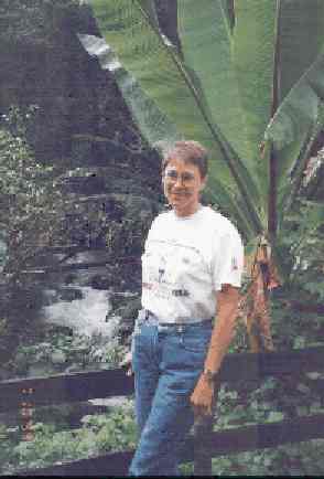
We took a bus to the Eduardo Rúiz National Park, located within the city of Uruapan. Inside the park is the origin of the Cupatitzio River (which means "singing river"). There were cobblestone paths through magnificent vegetation, flowers, trees, rivers and waterfalls. During the afternoon we had to take cover from a heavy rain. Afterwards we had lunch at the Plaza Urani in the park, which had wonderful, inexpensive food. We each had sauteed chicken breast with lots of garlic, fried potatoes, guacamole, tortillas, and the most wonderful hot chipotle salsa. (We bought some to bring back.) We were also served the best freshly prepared pineapple juice I'd ever tasted. (To see a picture of me in the Parque, click HERE.)
July 11, 1999
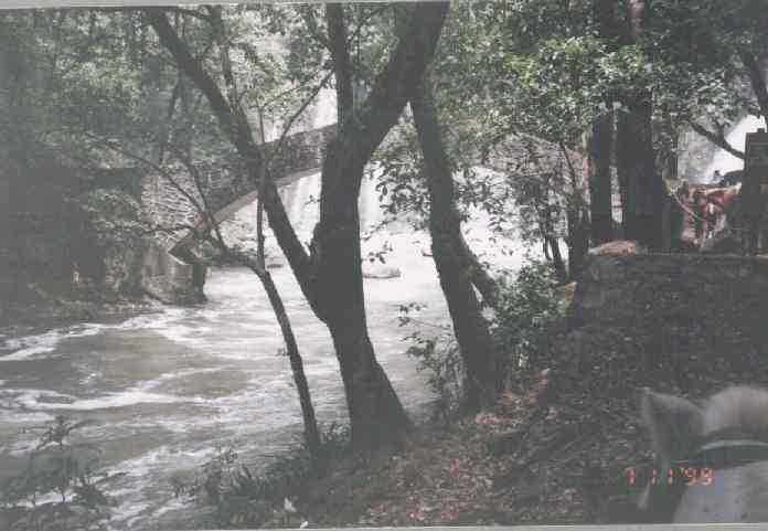
On the way out of town, we found (with some difficulty) the location of the Tzararacua waterfall. I did a horseback ride down steep paths to the falls and the river running below while T.C. chose to wait above. (To see a picture of the river beneath the falls, click HERE.) You'll see my horse's ears in the lowr right-hand corner.
Then we continued on to Pátzcuaro, about 40 miles through more beautiful mountain scenery. Pátzcuaro is a colonial gem with friendly residents. The city was developed as a religious center and its early inhabitants believed Pátzcuaro to be the doorway to heaven where the gods ascended and descended.
We stayed at the Hotel Posada San Rafael, 250 pesos ($27) on the Plaza Grande where they had free interior parking. The room was charming, but had no privacy unless the wooden window shutters and doors were closed, which made it very dark. The main drawback was the smell of the water from the shower, toilet and lavatory. Of course, we never drank anything but bottled water in Mexico, but in Pátzcuaro the very smell of the water was awful. (To see a picture of the the Plaza Grande just across the street from our hotel, click HERE.)
Pátzcuaro is a wonderful town for shopping because of the textiles, copper, wood carvings, lacquer work, and straw weavings made in the area. Pátzcuaro has Indian roots that still run deep, and here you have the feeling of traveling centuries back in time.
Monday, July 12th
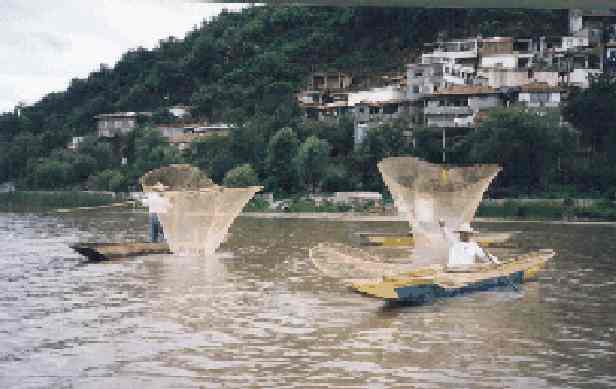
Pátzcuaro is known for its lake, one of the world's highest at 7,250 feet. We took a 20-minute boat ride across Lake Pátzcuaro to Juanitzio Island. There are no cars on the island. Steep stairs wind around and up to the top of the hill which forms the island, and along the route are continuous open-air shops and restaurants. At the very top is a commanding 131-foot statue of Don José Maria Morelos y Pavón, a hero of the Revolution; inside the statue visitors can climb a circular stairway to the top and view murals of scenes from the hero's life. (To see a picture as we approached the island, click HERE. For a picture of the huge statue, click HERE. To get an idea of the size, reference me standing at the base - you can barely see the white front of my jacket.)
The islanders are able fisherman with their large, fragile-looking nets of such delicate texture and wide-winged shape that they've been compared to butterflies. The fisherman catch small white fish that are sold fried at most of the open-air restaurants along the path to the top of the island. (To see a picture of the fishermen and their nets, click HERE.)
Back in Pátzcuaro, we explored the Basilica, various markets, and checked and sent e-mail from a very nice cyber café. That night we had a delicious dinner at a sidewalk restaurant near our hotel.
July 13, 1999
We left Pátzcuaro at 11:30 a.m. and headed for San Miguel de Allende on Highway 43. Going toward Morelia, we soon encountered an excellent four-lane divided highway. Then we turned on Highway 51 toward the large metropolitan city of Celaya with 317,000 people. In Celaya they had McDonald's, Kentucky Fried Chicken and Pizza Hut (yuck!)- but none of them served coffee. We wanted to fill our mugs. Finally we stopped at a Pemex gas station, where they had hot water and instant coffee for sale.
We encountered misleading road signs in Comonfort and got lost. We slowly wound our way over rutted dusty roads, across some railroad tracks, and finally, when we were thoroughly confused, a kind cab driver led us back to the right road.
We arrived in San Miguel de Allende late afternoon. T.C. had been in San Miguel before and he remembered the Hotel Quinta Loreto, which is similar to a motel with parking right outside each room. We planned to stay there because it is off the street and parking is secure. We found the hotel with almost no trouble. It was 290 pesos ($32) with a small discount if we stayed a week. The hotel had a lovely garden with walkways, a fountain, and benches.
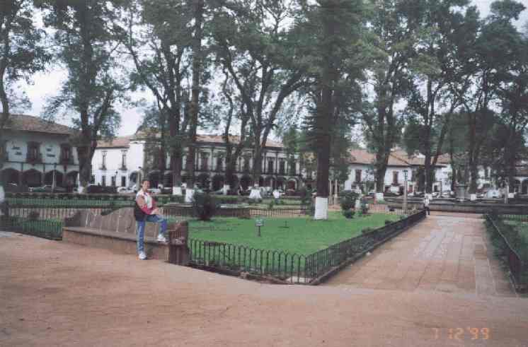
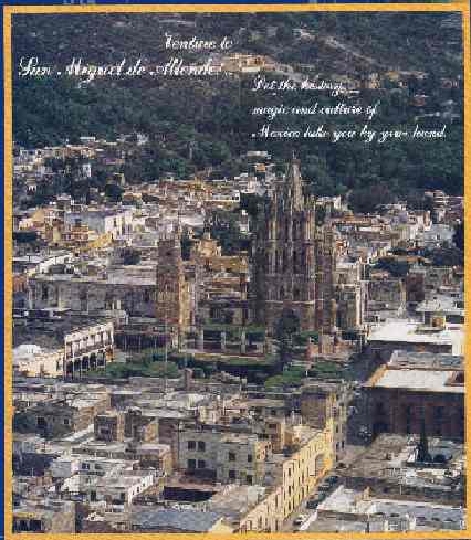
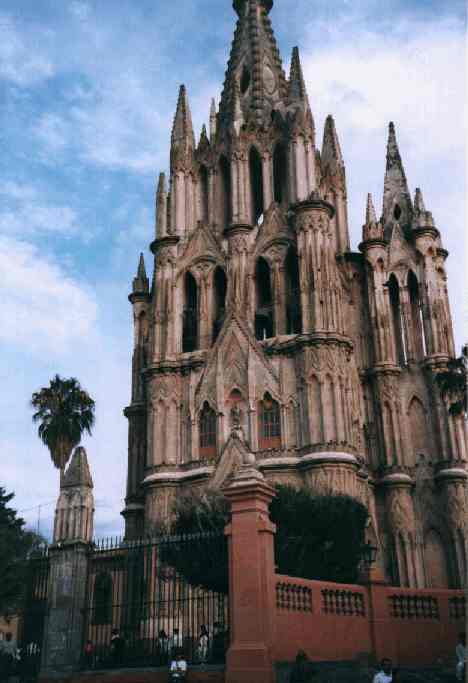
San Miguel was founded in 1542 and has been declared a national monument. Most of the buildings date from the colonial era and new buildings must conform to existing architecture. Many of the shops, hotels, and restaurants are housed in beautiful mansions dating from the silver-mining days in the region. (To see a picture of the city, click HERE. For a picture of the beautiful Parroquia (parish church) which is San Miguel's best-known landmark, click HERE.)
Located 180 miles northwest of Mexico City, it is near the geographic center of the country. At an altitude of 6,300 feet, it has a nearly perfect climate with sunny days and cool nights year round. It is one of Mexico's most popular cities, and it draws an increasing number of expatriates (including many writers and artists) who establish permanent residence here. San Miguel offers excellent art and cultural events. Numerous art exhibitions are held throughout the year in the acclaimed Allende Art Institute. There are thermal waters, sports facilities such as golf, tennis, horseback riding, ballooning and off-road mountain biking excursions through spectacular mountain scenery. San Miguel's inhabitants are warm and friendly.
The town has long been an arts and crafts center, and shopping for fine arts and Mexican folk art is a pleasure in the many galleries, stores and markets. Great bargains can be found in the handcrafts of brass, wool, papier mâche, blown glass, ceramics, stone work.
San Miguel is an important cultural and intellectual center, offering classes and workshops in a variety of subjects: writing, languages, painting, and photography - to name a few. (Visit this excellent web site to read more about SAN MIGUEL.)
The first two days in San Miguel we had comida (late lunch) at the hotel restaurant. It was adequate. Lots of food, but not much variation each day. We had chicken with mushrooms, potatoes, steamed cauliflower, carrots, a salad, lentil soup, bollios. a pitcher of limeade, mango cake or lemon pie. Comida each day for the two of us was 100 pesos plus a 20 peso tip ($13).
We explored the large market near the hotel, which had a wide selection of handcrafts. We found that driving/parking in San Miguel is very difficult because of the narrow cobblestone streets. Walking is usually the preferred method of transportation. Taxis are inexpensive for destinations farther than one cares to walk.
We shopped at the supermarket (called "Gigante") because we had a cooler with us and we usually ate sandwiches of some kind in the room at night, along with mangos, papaya or bananas. We had a better variety that way, as we got really tired of the sameness of restaurant food.
July 17, 1999
I took a field trip to Guanajuato. (T.C. went to nearby Mineral de Pozos in my car, which is another old silver-mining ghost town.)
Guanajuato also owes its foundation to the rich silver mines that were discovered by the Spanish from 1548 onwards, and it subsequently went on to become the richest city in Mexico in the 16th century. The city is a beautiful example of art and architecture with its magnificent neoclassical structures. It retains a peculiar combination of Mexican and European qualities. There are many underground streets and tunnels to relieve the city's traffic. Some of the tunnels were converted from dry riverbeds. It is a flamboyant city, a maze of plazas, byways, picturesque streets, dramatic tunnels.
We visited several museums, including the Museum of El Quijote with its international collection of sculpture, paintings, drawings, graphics, etc., with the theme of Don Quijote de la Mancha. The work of many famous artists is exhibited, including that of Salvador Dali and Picasso. (Every year in October, the state of Guanajuato sponsors the International Cervantes Festival, two weeks of performing arts from all over the world.)
We also walked through the Teatro Juárez. Its construction began in 1872 and was completed in 1903. The theater is now the venue for many productions, especially during the Cervantes Festival. Outside, its façade is crowned by bronze statues of the Greek muses. Inside, the five-story U-shaped theater is embellished with carved ornamentation of red, gold, and blue and columns and garlands and elegant décor. It is the only theater in the country that has conserved its original furnishings. (Here's a great web site to read more about GUANAJUATO.)
July 18, 1999
In San Miguel, we took the House and Garden tour, offered through the Biblioteca Pública (public library) every Sunday. The $15 fee for the tour goes to support various projects benefiting the youth of San Miguel. Visitors are able to tour three different homes each week from a list of more than 100 of the city's most interesting colonial and contemporary houses. Like much of the construction in Latin America, the view from outside usually is simply a drab wall along the street or sidewalk. Then I'm always amazed to find many of them open inside onto pretty, flower-filled patios and beautifully decorated interiors.
July 21, 1999
We departed San Miguel headed for Houston at 8:00 a.m. T.C. was driving. He made an illegal turn and was stopped by the police. They asked him 100 pesos for the "ticket," he offered 50, and they agreed. We were on our way again.
Toward San Luis Potosi, there were beautiful valleys and farms, and we came to a nice four-lane divided road after we turned off 51 onto 57. After we had gone 61 miles from San Miguel, just after entering the state of San Luis Potosi, we were back in the mountains again. Each state is responsible for maintaining the roads within it, and the roads in the state of San Luis Potosi are noticeably in worse condition than in the state of Guanajuato. The road was still four lanes, but it was bumpier and had some holes. The day was cloudy, and when we stopped at a Pemex gas station, we found it was chilly, too.
We traveled up Highway 57 almost all the way to Saltillo, then turned off toward Monterrey, and then up Highway 85 to Nuevo Laredo. Just outside of Saltillo we were able to take a toll road almost all the rest of the way. The tolls are expensive (the total was about $33) but it's worth it. The roads are excellent, the traffic is very light, and the police don't seem to care about enforcing any speed limits.
We traveled back through mountain desert country, valleys of forests of cactus - many of them in bloom. We crossed the Tropic of Cancer as we neared Matahuala. At Saltillo the weather began to get much warmer.
In Nuevo Laredo we had to find the place to surrender the car permit. T.C. remembered where it was located - there are no directional signs. We found it with no trouble, and this time the procedure was quick and easy. It took only about 10 minutes to handle the necessary paperwork, and then we went to the border to enter the U.S.
We had made such good time that we decided to continue on to Houston and arrived at 10:45 p.m. The entire roundtrip had been about 2,800 miles. Splitting joint expenses, the trip cost each of us about $34 a day - and that included splitting the cost of the car insurance. (I spent an additional amount - about $350 on shopping and gifts - which still made my total expenditure less than $50 a day.)
Two things I haven't mentioned in the above account of the trip:
(1) Traveling by car in Mexico, you'll invariably encounter numerous checkpoints where the Army stops traffic. Sometimes they're in uniform, sometimes not. They will probably ask you where you're going and where you've been. After having lived in Mexico, T.C. said he found that it's a good idea to tell the officials you don't speak Spanish - even if you do. That way they have to communicate with you in English, which pretty much eliminates lengthy conversation. We had no problem at any of the places we were stopped.
(2) Be alert for "topes" (speed bumps) in every town you go through. Sometimes they are not announced by warning signs and can be bone-jarring if you go over them at any speed.
Happy traveling!
Copyright 1999 * Dottie Atwater
Return to Dottie's Home Page